
Assalamualaikum and hi peoples
On 17/04/2012-18/04/2012, I have joined the field trip to several different places. The entry on this time will be written in the English language, and i wanted to told you what actually i am doing when i was there , this entry is like a report style , i am so sure everybody knew how to write the report and also how to read english right ? My advice would be ; Please do not read if you feel it is not beneficial for you . Just who ever so interested in the knowledge can freely enjoy the excitement in this entry of my trip . Firstly , the main objective for this field trip is ;
On 17/04/2012-18/04/2012, I have joined the field trip to several different places. The entry on this time will be written in the English language, and i wanted to told you what actually i am doing when i was there , this entry is like a report style , i am so sure everybody knew how to write the report and also how to read english right ? My advice would be ; Please do not read if you feel it is not beneficial for you . Just who ever so interested in the knowledge can freely enjoy the excitement in this entry of my trip . Firstly , the main objective for this field trip is ;
- To make sure all the student understand all the knowledge been given during lecture time.
- To identified the fresh specimen during field trip relevant with the theory in the lecture time.
- To see clearly all the earth process and material with raw eyes.
Before we went to trip , my friends and i need to gather infront of my university's building for briefing about the trip for today , after that , we do some of the streching .
As a introduction ;
 |
| to much lightning on kerk's face , wonder why ? LOL . |
 |
| streching time |
The field trip was handling by SBG 1 student 2011/2012 session. Since the student in first year and first time went to field trip so they need a senior came along. The field trip was present towards all the class. The class member be informed what they necessary thing should bring along during field trip. There several places needed to go at Jeli, Kelantan area such as Gunung Reng, Kampung Kalai, Lata Janggut, Kolam Air Panas and Lata Renyok. But due to time consuming only three places did went it is Gunung Reng, Kampung Kalai and Lata Janggut. That is for first day field trip.
The second day we went to Perak Darul Ridzuan, Museum Archaeology, Lenggong and Museum Geology, Ipoh. During this time student been introduced to the entire sample that collected by the professional. It been displayed inside the museum with explanation to make the entire visitor easy to understand. It original specimen that been displayed.
During earth material lecture time we are exposed to the types of rocks. There 3 types of rocks which are sedimentary, igneous and metamorphic. At this field trip we can identified all type of rock seems all the location went had dis kind of rock. On the other hand, during earth process lecture we were explained about formation of rock through rock cycle and the effect to the rock due weathering. Some more we need to take all kind of rock that found at the field trip location. The rock be collected and put inside the bag given by laboratory assistant. We also learn how to use GPS and compass at each places we went. We need to record all the reading shown. It an early introduce to the equipment even it not included inside the lesson. Seems we were going to use it up coming so it a basic thing needed to learn .
As for the report on the first day ;
DATE : 17th May 2012
LOCATION : GUNUNG RENG,JELI
N 05˚42’ 54.1”
S 101˚44’ 43.5”
TIME : 08.13 a.m.
ELEVATION : 127m
At this location we split into our group and work together observed surround us. Firstly we used the compass identified the South and read the coordinate from our place stand. We got 30˚ NE for compass reading. We practice again what had learn before went to field trip. After that we used GPSmap to make sure the accuracy of the coordinate. Gunung Reng spectacular limestone outcrop containing a bat-infested cave. It actually not a cave, it is a stone that deposited due to water level of sea decrease and the stone appear. The cave dominant is limestone it contain calcite. It because the rocks that bee taken from the cave react with hydrochloric acid. We be explained that more crystalline got possibly it can change to marble. The composition change to metamorphic. It also changes the texture, structure due to foliation. Limestone colour is chalky and the texture more earthy. Chemical weathering makes the formation of cave. The chemical weathering is a process in which rocks are broken down or transform parent material. There an agent of oxidation, hydration, dissolution and solution. This formation of Gunung Reng may be due to solution. It is cause solution where the process of solution and carbonation goes together. Whereas here limestone be identified as the particularly susceptible to solution when they are attack by water containing carbon dioxide. When rain falls the acids combine with carbonate then carbonate acid form. The rain drops form stalagmite and stalagtite. As we informed certain cave got water flow. If can see inside the cave the roof look like grooved it is because normally the cave inside the sea. The sea water come from horizontal while rain drops come vertically. Therefore erosion occurs after a year it appears.
 |
The full view of Gunung Reng, as can see there a plant grow at the wall of cave. It show there organic activity occurs.

Used the compass to get the coordinate of Gunung Reng which is 30˚NE.

This is the rock that identified as limestone after we broke it into small pieces. It show shinny luster.
To confirm it is a limestone or not we need to test with hydrochloric acid. As we test the reaction positive. There a bubble when a drop of hydrochloric acid pout onto it .
CaCO₃ + HCl → CaHCO₃
(calcite) (hydrochloric (calcium
acid) carbonate)
DATE : 17th May 2012
LOCATION : SUNGAI TADOH,GUNUNG RENG,JELI
N 05˚42’ 54.2”
S 101˚44’ 43.9”
TIME : 09.30 a.m.
ELEVATION : 115m
This river located nearby Gunung Reng, it just beside the cave as this place become recreation place so it looks beautiful has the river. As the cave have a limestone as the formation of it. The river having marble as it composition of the rock that dumps at the side of the coast. The formation of marble occurs when the heat hit the limestone and changes all the composition of the limestone to marble. It actually intrusive rock, fresh rock inside the earth but when weathering happen or it been exposed it will deposited as igneous rock. The igneous rock form of limestone that containing calcite and when heat occurs surround it changes happen and become marble. The luster soft glassy if saw the marble.

At the edge of the river can see the marble form. It large amount of marble along this river. It can see clearly the colour different from limestone.

The fresh marble that taken at the edge of river. The soft glassy luster can be seen clearly. The texture is coarse.
DATE : 17th May 2012
LOCATION :KAMPUNG KALAI,JELI
N 05˚45’ 39.7”
S 101˚44’ 47.9”
TIME : 10.00 a.m.
ELEVATION : 112m
Kampung Kalai really well-known for its gold mine. The villager’s majority here pan for gold and rubber tapping. It hard actually to pan for gold. As gold is tiny particle and combined with the rock so it hard to notice it. It also can combine with pyrite which is similar like gold. But then the pyrite more shiny than gold. Original gold not shiny but after process the gold turn shiny. The luster for pyrite is metallic. It fractures uneven. We need to go inside the river to pan for gold. At first need to dig the soil inside the water and put into the pan. The pan needs to dip in the water to separate the unused item with gold .

The first attempt to pan for gold. All the soil put into the pan.

The soil need to be filter until can see the gold .

The gold that get after pan for an hour.
A tiny gold found. Can be seen the colour dim compared to pyrite.
Never missed to snap some pictures for my memories since i reached there ;
Never missed to snap some pictures for my memories since i reached there ;
DATE : 17th May 2012
LOCATION : LATA JANGGUT,JELI
N 05˚40’ 13.2”
S 101˚46’ 12.9”
TIME : 01.30 p.m.
ELEVATION : 106m
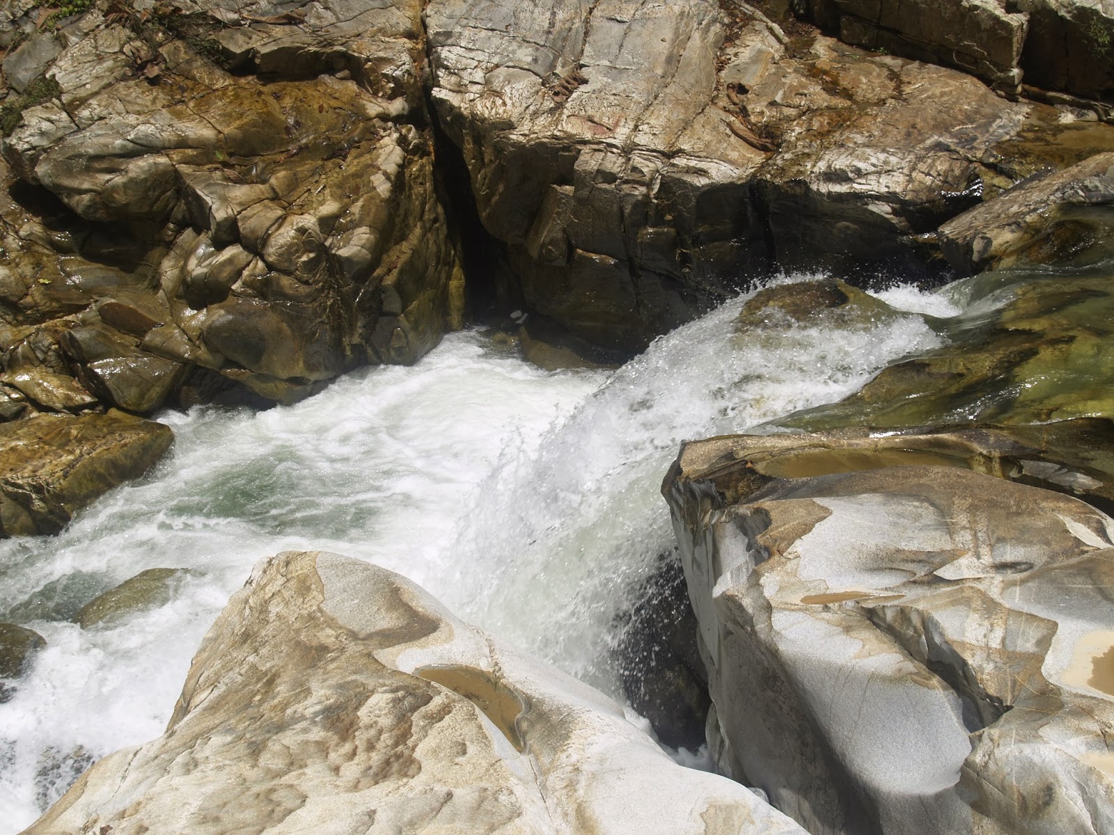
Lata Janggut is a river and got waterfall but not the big one. It one of the attraction for Jeli,Kelantan places to be visit. As we reached here, we learn about the formation of rocks. A lot of knowledge can gain here. The rock here majority are granite. The surface of the granite here is smooth. As granite is an igneous rock, it actually comes from intrusive rock deep inside the earth. The granite composition contains quartz, feldspar and others. The black colour that attach to the rock is actually biotite while the pinkie colour that attach is autoclase. Grey colour of granite is intermediate igneous rock. We can see the dominant is the light one. The river structure happen cause of original activity. The big rocks that usually people will stand over it actually batolite structure. It is a big form of igneous rock. The weathering occurs so that the rocks break and undergo decay under the influence of the atmospheric agencies like wind, sun, frost, water and organisms. The whitish that can be seen on the rock actually a secondary mineral. The secondary mineral exists after the fracture open and it also come from chemical weathering. The vein on the rock is mineral deposit onto it. It occurs after the process undergoes. At the vein we can notice quartz and cacite. Therefore got two type of vein it is calcite vein and quartz vein. Moreover, we can see the streambed is material transported by water river. The sediment boulder also can be seen here. It due to downslope movement of earth material, primarily under the influence of gravity without the aid of transporting medium such as water and wind. It is call as mass wasting. The layer form as we can see onto the rock it is spheroidal weathering. It is multidirectional attack. We also can see fount at the surface of the big rocks. It due to the movement may be on tectonic activity before. The join between rocks shown no shifting occurs. There also a valley where water flow between it. It bigger actually and when water keep on flow between it, spread out occur and a river is form. The intrusive rock compiles with tectonic activity and broke into pieces therefore a river is formed. The join of fracture that can see there is due to tectonic activities. The atmospheric pressure higher than the water pressure. The water come from spring with two conditions such as inner (impermeable) and outer (permeable). We also can see a pot hole. The pot hole occurs because of river bed. The rocks transit from a higher part to lower part and hit the rock down one. As it been hit so many times the surface being hit the rock erodible and become smooth. Finally the pot hole appears .

The river and rock at Lata Janggut,Jeli Kelantan.


It is igneous rock, granite. The black is biotite while pink is autoclase. The white is quartz .


The join between two rocks that can be identified at Lata Janggut. Maybe from tectonic activity .


Fracture and vein on the big rocks. The vein clearly seen. It contains calcite vein and quartz vein .

The join of fracture can be seen here it is due to the tectonic activity million ages ago .


The small waterfall is actually formed from the water flow that is before a valley. The water hit the rock until it broken and split into two .


The pot hole that occurs due to weathering process.
For the second day report and activity ,
DATE: 18th May 2012
LOCATION: Museum Archaeology, Lenggong , Perak
TIME: 12.00 p.m.
The second day field trip we went to a museum where all the fossil and sample of rock been displayed. The first museum we went is Museum Archaeology at Perak. It located inside the village of rural state called Lenggong. The museum been divide by three section the first is the fossil and a rocks been displayed. The second section where it explained about historical thing and the third section is a geology park. The geology park they displayed the sample of rocks that be found near a Perak state. It shown granite, quartz, Lawin rhyolitic tuff, Lawin basin, suevite, Toba ash, alluvium and limestone. It displayed there with the description each of it. The Toba ash we be explained that it occur during an explosion during volcanoes. The ash went through all miles to the other country. It is blown by the wind. The museum showed all the history of rocks. The chronology of rock also been shown there. Not only had that inside it tells us about equipment used to find fossils and rocks. The decoration of the museum also makes us really feel like inside the cave because got stalagtite and stalagmite. The main course of this museum is The Perak Man that found at Gua Gunung Runtuh. It is buried as fatal position with legs tucked towards chest, his right arm touching shoulder and his left arm bent so that his hand would rest on his stomach. It is the oldest human skeleton found at Peninsular Malaysia. Inside the museum also tell us about prehistory. It tells us about Palaeolithic to Neolithic. Other than that, it shows all the prehistoric Homo sapiens used the rocks as equipment to handle all the daily life.

All the rocks are shows that they use daily life. Some of the rock as a knife.

This is an ash collected at the volcanic ash around the Perak state.

This is a stalagtite that they make as replica inside the cave.
 This is a stalagmite that they make a replica look really like inside the cave.


This one of the sketch of people prehistoric. They write on the rocks.
THE PICTURE OF GEOLOGY PARK


DATE: 18th May 2012
LOCATION: Museum Geology, Jabatan Mineral dan Geologi, Perak.


So , as the conclusion in this field trip make more clear all the lesson that been taught inside lecture time. It also makes us identified fresh sample compare inside the lab. The fresh sample is good because we can examine it more detail. It also opens the mind of student to see the scope of working and the lesson they need to focus on. As went to museum we can be notice all raw material until it be process. It scope of working also not limited as we thinking. Other than that we can know the history of rocks where does it come from. It very far different when practical and theoretical study. We can more understand with practical rather than only hoping on theoretical.
that all .
that all .

note : memories teached us how to be the better person in the future , take what you need and throw the unnecessary thing from your life , step forward to the better future . Adiosa !